
How highway projects have (not so subtly) destroyed black communities, even in Alaska.
Back in May, The Root published A Timeline of Events That Led to the 2020 ‘Fed Up’-rising
The list points out some very specific events that go back over four hundred years, yes, 400 years. This slow boil is marked by some milestone events in which state, federal, and local governments have disenfranchised black citizens like the passage of the Jim Crow laws, suppressing civil rights protests and a litany of transgressions on individuals by law enforcement officers and other officials.
There is, however, another significant contributor that I feel is largely overlooked and I don’t mean in the context of the Root article, I mean overlooked by white people in general. I’m talking about the wholesale destruction of predominately black neighborhoods through the interstate highway program.
The Dwight D. Eisenhower National System of Interstate and Defense Highways, commonly known as the Interstate Highway System was authorized by the Federal-Aid Highway Act of 1956 and declared “completed” in 1992 with a total of 48,191 miles built.
In recent years, people have become more aware of the negative impact the interstate system ultimately had on the urban centers of American cities. The decline of downtown, loss of historic buildings, public transportation, and the generally unaesthetic nature of the highway itself have all been realized but few have come to terms with the socioeconomic impact on black Americans.
During the early days of the Interstate Highway System construction, the US was in the midst of a massive transfer of wealth and productivity from the city center to suburban communities further away from the city than even the second and third ring neighborhoods. Americans were migrating to communities several miles away from the urban center, thanks to the automobile, and an abundance of newly available, affordable land. They left behind everyone that was financially unable to do the same either due to actual financial status or underhanded tactics like the widespread practice of redlining. The insolvency of cities from loss of tax revenue and subsequent lack of maintenance coupled with the obtrusive, freeways bisecting the neighborhoods left little to be desired in those communities.
OK, so, did anything like that actually happen in Anchorage?
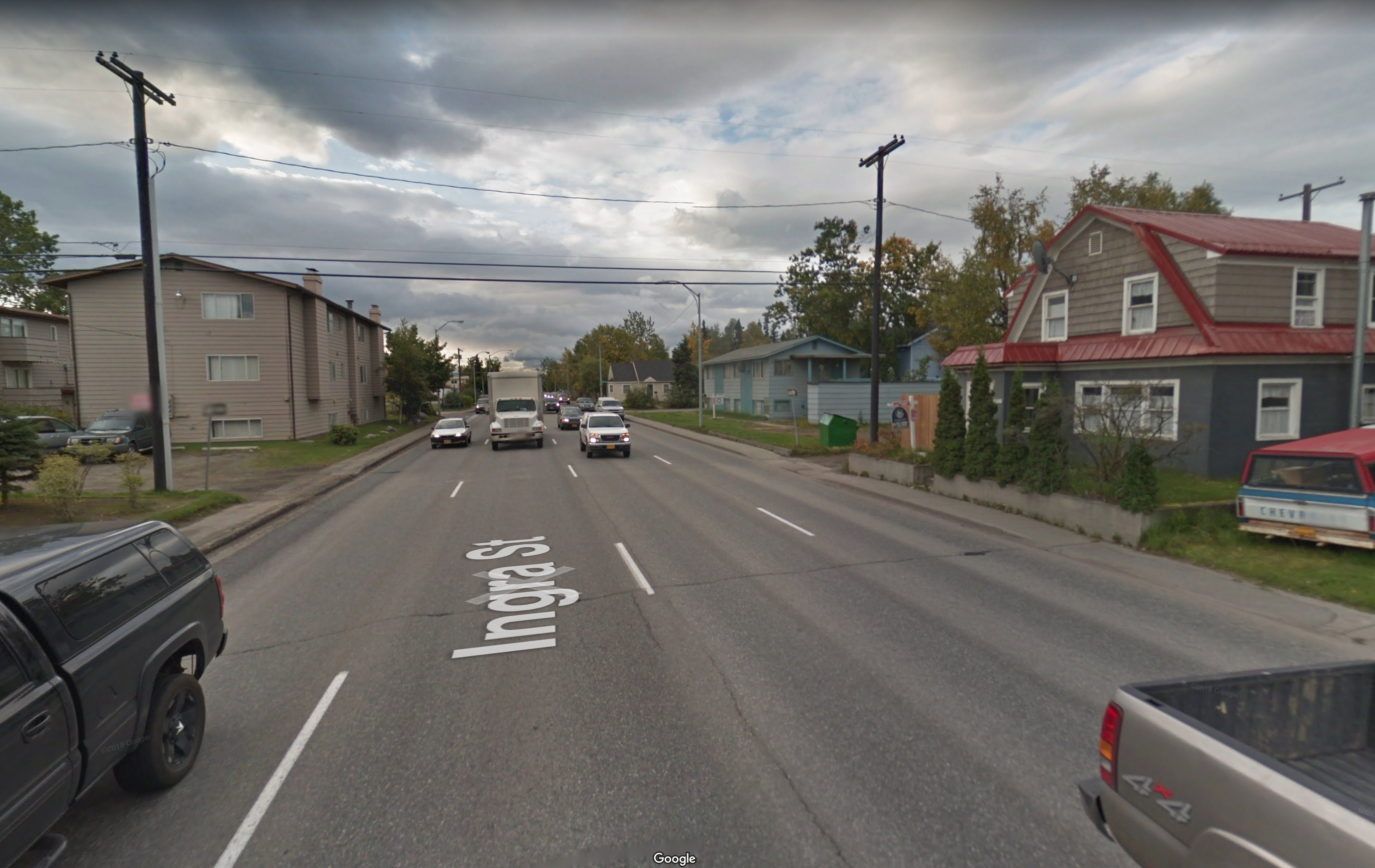
On a much smaller but equally significant scale, yes. Have you ever had a tourist ask you how to get to Highway 1? If you’re from Alaska and haven’t done many road trips in the lower 48, you’re probably not accustomed to the thinking roads in interstate number format. Highway 1 includes the Sterling, Seward and Glenn Highways, it also absorbed two neighborhood streets along the way: Gambell and Ingra. These two loud and dangerous surface thoroughfares have become known as “the couplet”, they trisect the neighborhood of Fairview leaving a small island of considerably (now) less valuable properties stranded in the middle.
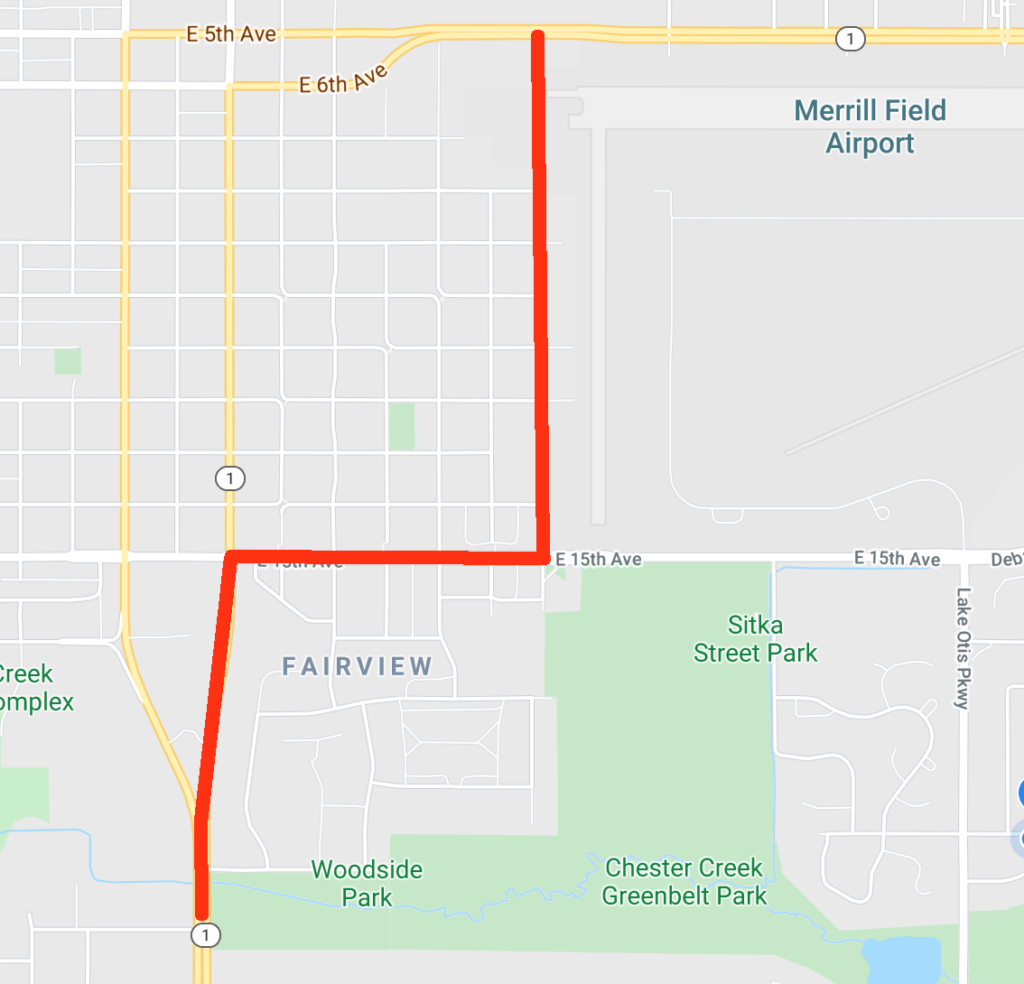
I’m not a traffic engineer but when I look at the map of the couplet area, it seems entirely possible that the highway could have easily absorbed a small section of 15th Avenue to the East of the couplet and traveled along the Western edge of Merrill Field rather than punching straight through the neighborhood. Variations of this route have been considered on previous AMATS improvement plans but why it wasn’t chosen initially is something to consider.
Fairview was an independent community until being annexed by Anchorage in the 1950s and the neighborhood was one of the only places in Anchorage where blacks were permitted to buy homes. Today, the conditions of the roadways and possibility of eminent domain being exercised for future road projects create uncertainty and discourages investment in the couplet area leaving a physical manifestation of disinvestment that is evident in the buildings there.
In recent years, Fairview has seen some very encouraging investment. Houses and apartment buildings have been renovated and some new construction has rendered some very appealing pockets within the old neighborhood. Fairview’s proximity to downtown and the neighborhood’s own local services make a renaissance there very likely in the near future. However, for many, the couplet area, specifically Gambell street between 13th and 14th Avenue is the bruised face of Fairview and gives the entire neighborhood an undeserved, bad reputation.
The H2H (highway to highway) project, a $581M plan to connect the Seward Highway to the Glenn Highway would have alleviated some of the issues caused by the couplet by utilizing a cut and bury roadway to move the high-speed traffic underground, reducing noise and making the neighborhood walkable again. In 2009 a commercial building on 15th Avenue was renovated and designated as the H2H project office and by 2012 the project seemed to have been completely abandoned in favor of a new interchange for Muldoon Road (completed) and the Knik Arm Bridge (also abandoned).
Image: Looking South on Ingra Street aka Highway 1 – Google Maps
The first plan to connect Glenn to Seward, pre-earthquake, was indeed to cut around the bulk of Fairview and down Orca Street. This was rejected after the earthquake in favor of expanding Gambell/Ingra. Was both more direct and cheaper.